Sunday, 26 May 2019
Saturday, 25 June 2016
DAY 69 - ALBARON TO SAINTES-MARIES-DE-LA-MER
The last day of our trip began with a walk along the road, to the backdrop of the Camargue rice fields.
 |
| Setting out among the Camargue rice fields |
After a few kilometres we turned into an inviting path leading to the lakes. The rest of the day's walk was spent crossing the wetlands of the Camargue, which extend right down to the outskirts of Saintes-Maries-de-la-Mer.
 |
| An inviting path |
We had been looking forward to seeing the fauna for which the Camargue is famous - flamingos, bulls, and white horses. We had also been informed by many people as we travelled through France that the Camargue is known for the number and size of its mosquitoes. We saw all of those animals during our walk today, as well as a variety of other birdlife.
 |
| Not sure whether these are African or European swallows |
 |
| Camargue checklist - flamingos |
 |
| An inviting bench by the Étang de Vaccarès |
 |
| Camargue checklist - white horses |
 |
| Camargue checklist - bulls |
Before long we found ourselves approaching Saintes-Maries-de-la-Mer, the destination we have been walking towards since setting out from Dieppe 69 days ago.
 |
| The final stretch of a long walk - towards Saintes-Maries-de-la-Mer |
 |
| Entry to the town -the end in sight |
We walked through the town and down to the beach. We celebrated the end of our walk in the traditional fashion:
 |
| Ceremonial selfie at the Mediterranean Sea to celebrate the end of the journey. 1700 kilometres and 69 days after starting out from Dieppe, we arrived in Saintes-Maries-de-la-Mer |

Day: 69 (and final)
Distance: 24.51 kmWalking time: 5hrs 09mins
Elevation gain: 244 metres
Cumulative distance: 1706.07 km

We would like to thank all those who have been following this blog - family, friends, and those who have joined us on the way. We have had a fantastic journey and have enjoyed sharing it with you.

Friday, 24 June 2016
DAY 68 - ARLES TO ALBARON
It looked like today's walk was going to be flat and fairly uninteresting. As it was also quite short, we decided to spend a couple of hours wandering the streets of Arles before setting off.
 |
| A touch of culture in Arles - the Australian Walla Beer Café |
 |
| Self-portrait with pink car - Australian photographer in action |
 |
| Arles street scene |
 |
| Another street scene in Arles |
We had come to the end of the GR653D yesterday (it goes from Montgenèvre on the Italian border to Arles). Today we left Arles on the GR653, which takes the walker on the next stage towards Santiago de Compostela. In our case, it took us about 14 kilometres before we turned to go towards the Camargue.
 |
| Heading west on the GR653D from Arles |
As we had foreseen, the walk was flat, straight and fairly uninteresting. The landscape consisted of rice fields, with the odd sunflower field.
 |
| Odd sunflower field |
The GR653 was the last GR (Chemin de Grande Randonnée, or long-distance walking path) of our trip. The last 5 kilometres today were on a main road, with a wide verge for the comfort of walkers and cyclists.
 |
| Wide verge on the D37 for long-distance Australian walkers |
One landmark of note on the way in to Albaron was a memorial to the internment camp of Saliers, where 700 gypsies were interned by the Vichy government during WWII.
 |
| Memorial to the internment camp of Saliers |
Day: 68
Distance: 19.63 km
Walking time: 3hrs 50mins
Elevation gain: 187 metres
Cumulative distance: 1681.56 km

Thursday, 23 June 2016
DAY 67 - FONTVIEILLE TO ARLES
We headed out this morning through plantations of melon, apple and olive.
 |
| Heading out among the olive trees |
There wasn't a cloud in the sky.
 |
| Not a cloud in the sky |
After about 5 kilometres we came to the village of Fontvieille. We walked through the attractive old part of the village. Fontvieille is mostly known for its connection with Alphonse Daudet, the author of Letters From My Windmill, a short story collection which we had read during the preparation for our trip.
 |
| Watching the passers-by in Fontvieille |
 |
| Bust of Alphonse Daudet in Fontvieille |
Past the village, we followed the signs leading to Daudet's windmill.
 |
| Daudet's windmill |
We had decided to detour from the GR653D (the long-distance walking path we have been following) to visit the ruined Roman aqueduct and mills at Barbegal. They were well worth the detour.
 |
| Ruins of Roman aqueduct at Barbegal - well worth the detour |
 |
| On the aqueduct |
 |
| Provence - olive grove, blue sky, Roman ruins, Australian tourist |
The route from the ruins into Arles was uninspiring. When we rejoined the GR, it took us along the verge of the busy main road, and then on a major commercial road into the town.
 |
| A rare off-road section of the GR653D between Fontvieille and Arles |
Once in Arles, we found our way via the Roman amphitheatre and theatre to our chambre d'hôte.
 |
| The Roman amphitheatre at Arles |
After a bit of a rest, we went out and wandered about the town.
 |
| Catching some late afternoon sun at the Van Gogh Café |
 |
| 67th day in France, first urinal |
 |
| Tourist taking a photo at the Van Gogh Café |
Day: 67
Distance: 21.6 km
Walking time: 4hrs 25mins
Elevation gain: 269 metres
Cumulative distance: 1661.93 km

Tuesday, 21 June 2016
DAY 66 - ST-RÉMY-DE-PROVENCE TO FONTVIEILLE
Another fine day as we continued our trek through Provence. We started by walking back towards the site of Glanum, where we picked up the GR6 (another of France's long-distance walking paths) to take us towards Les Baux-de-Provence.
 |
| Today's tourists at the Ancients as we were leaving |
The path started as most GRs seem to, by heading uphill. It soon became somewhat of an obstacle course, with metal steps, security chains, and slippery rocks to contend with.
 |
| Walking on the GR6 presented some challenges |
 |
| A bit of a scramble |
We emerged on a plateau on the Alpilles, with distant views to both north and south.
 |
| Up in the scrub of the Alpille hills |
The path was fairly level for a while. We passed a group of horses with riders, a few walkers, and a few mountain bikers. Eventually the castle of Les Baux came into view.
 |
| I think we're going over there |
We entered Les Baux via the Chemin de l'Enfer (Pathway of Hell). When we got there we found we were not alone. Tourists had come from far and wide (judging by the languages spoken and the country identification codes on the number plates) to visit this unusual village.
 |
| Les Baux-de-Provence, like other "most beautiful villages in France", attracts large numbers of tourists |
We wandered the streets for several minutes before moving on.
 |
| Some historic sights at Les Baux |
 |
| Les Baux |
 |
| More tourists at Les Baux |
There were some excellent views of Les Baux, and its imposing castle, on the way out of town.
 |
| Looking back at the castle and village of Les Baux |
The next few hours were spent following the GR6 north to where it joined the GR653D, and then up and down in the Alpilles until we emerged at the Chapelle Saint-Gabriel. Our accommodation was just a short distance further on.
 |
| The Chapelle Saint-Gabriel |
Day: 66
Distance: 21.99 km
Walking time: 4hrs 33mins
Elevation gain: 535 metres
Cumulative distance: 1640.33 km

DAY 65 - PLAN-D'ORGON TO ST RÉMY-DE-PROVENCE
Another short day's walk in Provence, unless you add on the extra kilometres we covered sightseeing in St-Rémy-de-Provence after we arrived.
 |
| Walking by the orchards. As well as apples, there were also nectarines, plums, cherries, pears and olives. |
We were already in the country when we set off this morning. We navigated a way to Mollégès through the orchards.
 |
| The first bakery we came to in Mollégès had its weekly closing day, predictably, on the day we were there |
Mollégès looked large enough on the map to have a bakery, and we had hoped to pick up our daily bread there. Unfortunately, it was Monday, and when we saw a bakery it was closed. Fortunately, if unexpectedly, there was a second bakery in the village, and this one was open.
 |
| Shady rest stop in Mollégès |
We covered most of the distance from Mollégès to St-Rémy-de-Provence on the D31. The traffic was not too heavy. There were some cars, quite a few bikes, and even a walker with a large backpack.
 |
| A common sight on the quiet roads of Provence |
We found an off-road path to take us the last few kilometres into town. After a brief pause in the town centre, we went out to our hotel.
 |
| A scrubby path took us into St Rémy-de-Provence |
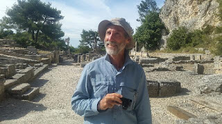
We had been keen to visit the extensive Greco-Roman ruins of Glanum, and after a brief rest we went out there (picking up our old friend the GR653D for some of the way). We enjoyed wandering around the ancient site.
 |
| Glanum - wandering without the backpack |
 |
| 'Les antiques' (the ancient ones) at Glanum |
 |
| Among the ruins at Glanum |
 |
| Enjoying the Greco-Roman ruins at Glanum |
 |
| Those shady characters again, this time at Glanum |
There was still time to visit the old monastery of Saint-Paul, where Van Gogh spent some time. Part of the monastery has been set up as a Van Gogh tourist attraction.
 |
| Van Gogh's bedroom |
 |
| Lavender garden at the Saint-Paul monastery |
Day: 65
Distance: 20.42 km
Walking time: 4hrs 11mins
Elevation gain: 260 metres
Cumulative distance: 1618.34 km

Subscribe to:
Comments (Atom)